Permits and Environmental Consultation
Securing permits for fieldwork can be challenging with long lead times. Although researchers are responsible for all permitting related to their fieldwork, the Battelle ARO team is available to assist and provide guidance throughout the permitting process. Battelle ARO can help identify required permits and provide expertise in specific areas that require local knowledge or other key agency contacts.
For more information on permitting and environmental compliance in the most frequently proposed Arctic locations, visit the links below. Please note that these are merely provided as a starting point, and it remains your responsibility to ensure you are meeting your permit and environmental obligations.
Alaska
Permits - Alaska
Land Ownership
The Alaska Lands Viewer can be used to obtain contacts for relevant agencies and tribal entities. Each landowner has their own permitting requirements, and therefore it is recommended that research locations be limited to as few land owners as possible to reduce permitting needs.
Search for a place you wish to work, explore the map or view the Help ? to print a contact list.
Click on the map below to open it in a new window.
Toolik Field Station
- Projects may be subject to various permitting requirements; therefore, Battelle ARO suggests that researchers plan 6 months of lead time for any activities, including construction support such as boardwalks, remote power systems, support buildings, etc.
- Researchers should budget for Bureau of Land Management (BLM) land use permit fees in their proposal budgets. Those planning any research activity on BLM lands must submit a permit application. On average, fees for the BLM are roughly $1,000 per year. If your project includes potential disturbance to the tundra from the construction of a building or a large tower, or if fieldwork includes numerous ground impacts from research activities (e.g., digging long trenches), the initial cost of the permit could be up to $5,000. See BLM section for more information.
- For additional information on permitting, see Permits and Policies | Toolik Field Station (uaf.edu)
Utqiaġvik
- All projects are subject to permitting. Battelle ARO assists with applications and fees for UICS staff who will plan and prepare applications for North Slope Borough (NSB) and UIC Land Use permits.
- Additional permitting may be required for researchers accessing sites on BLM-administered lands or waters in the National Petroleum Reserve Alaska, which includes Elson Lagoon. Please contact Donna Wixon for further information. Researchers should include costs for all BLM permitting direct-to-grant; the estimated BLM land use permit fee is $1000 per year.
National Historic Preservation Act (NHPA) Section 106, State Historic Preservation Office (SHPO) Consultation for Projects with Ground Disturbance/Archaeology Work
Any proposed work with ground disturbance or archeology work is subject to consultation with the SHPO and other interested parties under Section 106 of the NHPA.
-
Battelle ARO will assist the NSF with Section 106 consultation, and the PI will be required to provide the NSF all applicable information, including but not limited to:
-
A map of locations where you plan to do fieldwork (coordinates in excel, kmz, or shapefile are acceptable)
-
How will the ground be disturbed
-
What size area and to what depth
-
How will sites be accessed? By vehicle on existing roads, pullouts, by foot on existing trails and boardwalks?
-
When will your work be taking place
-
How many people will be in the field
-
- Any Archaeological investigation taking place on federal lands requires an Archaeological Resources Protection Act (ARPA) Permit.
- In the event that an archaeology project leads to the discovery of Native American human remains, funerary objects, sacred objects and objects of cultural property intentionally excavated or inadvertently discovered on Federal or Tribal lands, researchers need to comply with the Native American Graves Protection and Repatriation Act of 1990. Those processes are detailed in regulations available here.
Endangered Species Act – Section 7
Endangered species are protected under Section 7 of the Endangered Species Act.
-
Based on the location and type of work of the proposed project, review by USFWS could be required to determine whether the proposed project could impact endangered species
-
Battelle ARO will complete USFWS Section 7 consultation on behalf of the NSF and the researcher.
-
-
Section 7 of the Endangered Species Act states that each Federal agency shall, in consultation with the Secretary, insure that any action they authorize, fund, or carry out is not likely to jeopardize the continued existence of a listed species or result in the destruction or adverse modification of designated critical habitat.
-
Threatened and Endangered Species in Alaska are listed in the following table. All species subject to impact by a research project will need Section 7 consultation from the respective managing agency.
-
To determine if your work will impact any endangered species or their critical habitat, use the USFWS's Information for Planning and Consultation website, or NOAA's species distribution mapper
- The Marine Mammal Protection Act prohibits any person who is subject to the jurisdiction of the United States or any vessel or other conveyance subject to the jurisdiction of the United States to take any marine mammal on the high seas.
-
MMPA consultation will end with a no effects determination, a Letter of Authorization, or an Incidental Harassment Authorization.
-
USFWS is responsible for the conservation of polar bears and northern sea otters that inhabit Alaskan waters. Any action that could impact these species will be subject to review by USFWS.
-
NMFS is responsible for all other marine mammals.
Threatened and Endangered Species List
| Species |
| Managing Agency |
| Short-tailed Albatross |
|
|
| Endangered |
|
|
|
|
|
|
|
|
|
|
|
|
|
|
| |
|
|
|
|
| NOAA |
| Bowhead Whale | Endangered | NOAA |
| Finback Whale (Fin Whale) | Endangered | NOAA |
| Humpback Whale | Endangered | |
| Blue Whale | Endangered | |
| Cook Inlet Beluga Whale | ||
| North Pacific Right Whale |
| NOAA |
| Sei Whale | Endangered |
|
| Sperm Whale | Endangered | NOAA |
|
| NOAA |
|
|
|
| Olive Ridley Sea Turtle |
| NOAA |
|
| USFWS |
Unmanned Aerial Vehicles
- In general, UAV use is restricted in national parks except as approved in writing by the superintendent but could vary from park to park. Special use permits can be obtained by checking in with the park superintendent.
- The use of unmanned aircraft systems (UAS/drones) is no longer allowed for any US Fish and Wildlife Service supported or permitted use. This prohibition applies to the use of drones for commercial filming and scientific research, even if the use of drones was previously authorized via special use permit.
- For more information on UAS permitting, check out these links:
- If you plan to use UAS for your research, visit ArcGIS - Alaska DOT&PF Statewide Aviation UAS to search for your research location, and determine if there are any restrictions or additional permits you may need.
Land Disturbance and Vegetation Clearing
Projects that include Land Disturbance and Vegetation Clearing should be aware of nesting birds in the area.
| Times To Avoid Land Disturbance & Vegetation Clearing | Forest / Woodland | Shrub / Open | Seabird Colonies Incl. Cliff & Burrow Colonies | Eagles *e |
|---|---|---|---|---|
| Southeast | 15 April - 15 July *a | 1 May - 15 July *a,b | 1 May - 5 Sept | 1 Mar - 31 Aug |
| Kodiak Archipelago | 15 April - 7 Sept | |||
| Southcentral Lake Illiamna to Copper River Delta; north to Talkeetna | 1 May - 15 July *a,b | |||
| Bristol Bay/AK Peninsula north to Lake Illiamna | 1 May - 15 July *a,b,c | 10 May - 15 Sept | ||
| Interior north of Talkeetna to south slope Brooks Range; west to treeline | 1 May - 15 July *a,b | 1 May - 20 July *d | ||
| Aleutian Islands | N/A | 25 April - 15 July *a | 1 May - 15 Sept | |
| Yukon - Kuskokwim Delta | 1 May - 15 July | 5 May - 25 July *a,b,c | 20 May - 15 Sept | |
| Seward Peninsula | 10 May - 20 July *a,c | |||
| Northern including northern foothills of Brooks Range | N/A | 1 June - 31 July *a,c | ||
| Pribilof/Bering Sea Islands | 15 May - 15 July *a | 15 May - 15 Sept | ||
Table: Nesting seasons by habitat type and region and times to avoid land disturbance and vegetation clearing.
| ||||
Arctic Ocean
Vessel projects may be subject to review by NOAA/NMFS and USFWS under the Marine Mammal Protection Act (MMPA) and under Section 7 of the Endangered Species Act (ESA). MMPA and ESA apply to waters under the jurisdiction of the United states (200 nautical miles from the coast). Under the MMPA, “take” (harassing, hunting, killing or capturing) of any marine mammal is unlawful, 80% of marine mammals are listed as threatened and endangered and additionally protected by the ESA. Depending on the species that could be impacted, USFWS and/or NOAA/NMFS will need to be consulted. In Alaska, USFWS is responsible for sea otters and marine otters, walruses and polar bears while NOAA/NMFS is responsible for pinnipeds (including seals and sea lions) and cetaceans (i.e., whales and dolphins).
Battelle ARO can assist researchers in determining if their project will be doing work in areas that could impact marine mammals, threatened and endangers species, essential fish habitat or a species critical habitat. For projects likely to have adverse effects, the consultation process could take between 6 to 7 months.
For more information on consultation with NOAA and USFWS on Section 7 of the Endangered Species Act and the Marine Mammal Protection act:
Section 7 Consultations in Alaska | NOAA Fisheries
Marine Mammals Management | Alaska Region (fws.gov)
Marine Mammal Protection | NOAA Fisheries
Consultation on an Endangered Species | Alaska Region (fws.gov)
Additionally, all vessel projects need to consider any subsistence hunting conflicts. Researchers should plan to engage with local Arctic communities to ensure the vessel track is not infringing on subsistence hunting.
Subsistence information:
- Alaska natives have been hunting bowhead whales (Balaena mysticetus) for thousands of years. This traditional subsistence hunt is protected under the MMPA and hunting is allowed for registered members of the Alaska Eskimo Whaling Commission (AEWC). The map below shows the Bowhead Range and Seasonality (Source: ADFG, 2011).
- Click on the following link for more information on Bowhead Whale Subsistence Harvest
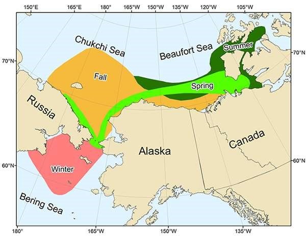
Bowhead Range and Seasonality (Source: ADFG, 2011)
Canada
Permitting requirements are dependent on where you are conducting fieldwork in Canada. For assistance with permitting, please contact arctic.planning@battelle.org.
Resources:
- Permit Applications
- Nunavut - Science Research License Application
- Yukon - Scientists and Explorers Act Licence
- Northwest Territories - Scientists and Explorers Act License
- Canada National Parks - Research and Collection Permit System
Greenland
- Science teams planning to work in Greenland must comply with all permitting requirements of the Government of Greenland. Permits required by the Government of Greenland may include:
- Any overnighting expedition in the National Park, which covers most of the Greenland Ice Sheet (see map)
- Access to protected areas such as the Ilulissat Fjord or the newly established UNESCO site outside of Kangerlussuaq
- Studies involving wildlife
- Studies involving cultural heritage
- When leaving instruments in the field for more than 2 months
- When carrying a firearm for bear protection (which is also required if working within the National Park)
- The PI should include Greenland Home Rule permitting fee costs in the grant. We recommend ~$800/year (based on 4000DKK fee).
- Projects working at Summit Station (or within Summit area allotment boundaries) are included under the Summit group permit, acquired annually by Battelle ARO. However, Summit area projects are required to independently submit a sub-permit application.
- If installing equipment within the Thule Air Base defense area, you must secure permission from the USAF command. Please coordinate with your Battelle ARO PM for more information as USAF command POCs change every season.
Resources:
Norway
Research Permits in Norway
General information on the Norwegian Environment Agency
Archaeological research or research that could impact historic properties.
- Any research that could disturb protected monuments and sites and their security zone (ie. Uncovering objects, small or large excavations, removal of objects and materials, undertakings within the security zone) require permission from the Directorate.
- The Directorate for Cultural Heritage is responsible for the management of all archaeological and architectural monuments and sites and cultural environments in accordance with relevant legislation.
Marine research
- Any research that is doing marine work in waters under Norwegian jurisdiction must send an application to the Directorate of Fisheries.
- Application forms and instructions
Animal research
- Any experimentation on animals in Norway needs to comply with the Animal Welfare Act.
- Most guidance on this legislation is only available in Norwegian, but the Act itself is available in English
- The Food Safety Authority has launched a webpage(in Norwegian) that outlines research activities that require review and approval.
Vessel/maritime research
- Any research that could affect maritime safety and navigation require a permit from the Norwegian Coastal Administration this applies to all work whether great or small, permanent or temporary, at sea, on land or in the air. For instance, Norwegian authorities would have to authorize the deployment of research buoys anstrong other installations at sea.
- Foreign state-owned or operated vessels, used for government non-commercial purposes, have admission to Norwegian territory only if they in advance have obtained permission through diplomatic channels. Applications for admission must be presented to the Ministry of Foreign Affairs or a Norwegian embassy
UAV
- The use of unmanned aerial vehicles (UAVs), requires an operation license from the Civil Aviation Authority
- Instruction to Register as a UAS operator
Helicopters, fixed-wing flights
- Helicopter and fixed-wing flights can only be conducted by CAA-licensed operators.
- Civil Aviation Authority
Svaldbard Specific
For more information on permits specific to Svaldbard.